Thunderstorms and Gusty Winds Lash Bengal as Monsoon Gains Momentum
IIE DIGITAL DESK : Kolkata, July 30, 2025 — The India Meteorological Department (IMD) has issued a warning for thunderstorms accompanied by gusty winds and heavy rainfall across multiple districts of West Bengal, especially in the southern and northern parts of the state. This intensifying weather pattern is attributed to a combination of a developing low-pressure system over the Bay of Bengal and a strong seasonal monsoon trough, now firmly established over Gangetic Bengal.
From Tuesday onward, scattered thunderstorms with lightning and winds ranging from 30 to 40 km/h are expected in Kolkata, Howrah, Hooghly, the 24 Parganas (both North and South), Burdwan, Jhargram, Purulia, and Bankura. In some areas, wind speeds may even surge up to 40–50 km/h, raising concerns about disruption.
As early as Thursday, weather officials have forecasted heavy rain (7–11 cm) in districts along the coastal and western margins of South Bengal. Specifically, intense showers are expected in South 24 Parganas, East and West Burdwan, Birbhum, Murshidabad, and Nadia—some zones even face orange-level alerts.
The sub-Himalayan districts—including Darjeeling, Kalimpong, Jalpaiguri, Cooch Behar, and Alipurduar—are forecast to receive heavy to very heavy rainfall through Thursday morning, which could result in flooding and landslides in vulnerable terrain.
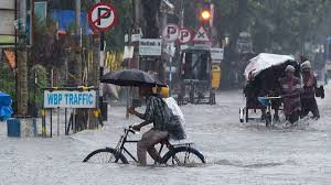
Kolkata’s Alipore recorded 38 mm and Dum Dum saw 57 mm of rain within 24 hours—while Salt Lake logged up to 81.3 mm, the highest in South Bengal during the period.
The IMD’s system analysis explains that the low-pressure zone over the Bay of Bengal is gradually shifting northwest toward Jharkhand—while a cyclonic circulation lingers—sustaining widespread rainfall across Bengal well into the week. Coastal waters are choppy, and strong winds of 35–45 km/h are forecast, raising alarm for fishermen and maritime activity.
Residents and local administrations are taking note. Kolkata experienced a late-evening thunderstorm that cooled the city following a sweltering Sunday. Meteorologist Sourish Bandopadhyay noted that while evening showers may remain sporadic, intensity is expected to escalate from Tuesday onward in both the metropolis and surrounding districts.
The forecast period suggests the monsoon's deep arrival in South Bengal, with a sustained spell of wet weather likely through Friday and possibly into the weekend. Forecasters have indicated that the threat of localized flooding, temporary infrastructural disruption, and waterlogging remains elevated.
Authorities in coastal regions have issued advisories asking fishermen not to venture offshore due to the turbulent seas during the next 24–48 hours.
While there are no active weather alerts for North Bengal yet, scattered showers with strong gusts are expected to persist even there. Officials are closely watching foothill districts like Jalpaiguri and Alipurduar, where moderate to heavy rain and thunderstorms remain likely.
West Bengal faces a throbbing onset of monsoon activity, with thunderstorms, gusty winds, and heavy rains intensifying across districts. As weather systems linger over the region, an unstable atmosphere has primed the region for further downpour and turbulent conditions. Residents are urged to stay indoors during storm alerts, avoid travel in flooded areas, and heed advisories issued by the IMD and local authorities.
You might also like!